Published: February 9th, 2024


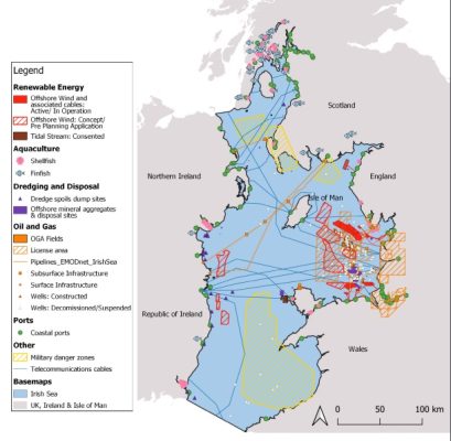
Fig. 1 Activities occurring in the Irish Sea. For data sources and more detail, see the ISN report linked at the end of this blog.
The Irish sea is bordered by 6 nations each with different focus and legislation when it comes to marine protected areas and marine spatial planning. Pressures such as industrial fishing, aquaculture, offshore renewables, shipping, pollution as well as military and recreational activity are all taking their toll on the vulnerable ecosystems which are found there (see fig. 1)
Each nation has committed to protecting 30% of its waters as Marine Protected Areas by 2030 and the ISN is calling on their governments to ensure that there is effective coverage within the Irish sea as part of this target. Over a third of the Irish Sea has been designated as Marine Protected Areas, however only around 5% is actually effectively managed and less than 0.01% is strictly protected. Each Irish sea nation is producing separate marine spatial planning documents covering a huge range of uses. The Irish Sea Network says all planners and decision-makers must collaborate and cooperate better and with urgency, to consider the Irish Sea as a whole, and ensure that the nature and climate crises are at the forefront during this process. Grace Carr, Irish Wildlife Trust Marine Advocacy Officer said:
“As we all know, nature does not recognise borders and so it’s imperative we take a cross-border approach when designating areas for protection, fishing and industry in this biodiverse area. With the new Irish MPA bill due to be released early this year, the knowledge sharing and collaboration within this report will make it an important tool when advocating for nature and ecosystem-focused Marine Spatial Planning in the Irish Sea.”